When people think of Lanzarote, they usually picture beaches, volcanoes and lunar landscapes. But what many travellers don’t realise is that the island is also a fantastic destination for hiking.
With its mild climate all year round and its surprisingly varied scenery, Lanzarote offers a wide range of trails that lead through volcanic craters, lava fields, coastal paths and remote corners of the island that many visitors never get to see.
In this guide, we’ve selected some of the best hiking routes in Lanzarote to help you find the one that suits you best. Whether you’re travelling with children, looking for an easy walk or searching for a more challenging trek, there’s a trail here for every kind of explorer.
Difficulty: Easy
Duration: 1–1.5 hours
Distance: Around 4 km
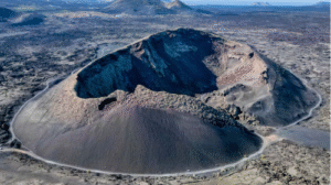
If you’re looking for one of the best easy walking trail in Lanzarote, Volcán del Cuervo is a great place to start.
This is one of the island’s most iconic and accessible volcanic trails. The route follows a circular path around the cone and even allows you to step inside the crater through a large opening in the rock — a unique experience that makes this walk especially memorable.
It’s an excellent option for families and casual walkers, as the trail is relatively short, well-marked and doesn’t involve any major elevation gain. Along the way, you’ll be surrounded by dramatic lava fields created during the great eruptions of the 18th century, which makes the walk not only scenic but also fascinating from a geological point of view.
If you’d like to make the most of the area, you can easily combine this route with a visit to Montaña Colorada, located just a few minutes away. A short circular trail takes you around this striking red volcanic cone, where you can admire its intense colours and see one of Lanzarote’s most impressive volcanic bombs — a huge block of lava thrown out during the eruptions.
Doing Volcán del Cuervo and Montaña Colorada on the same day is one of the best ways to experience the island’s volcanic heart, especially if it’s your first time hiking in Lanzarote.
Why choose this hike?
💡 W2W tip: If you want to explore this area in a deeper and more meaningful way, our World2Wander volcanic experience can help you discover not only the landscapes, but also the stories, geology and hidden details that make this part of Lanzarote so special. For more information, feel free to get in touch at info@world2wander.com
Difficulty: Moderate
Duration: Around 2 hours
Distance: Approximately 3 km
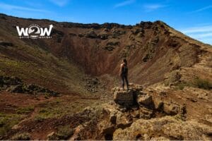
Located in the north of Lanzarote, La Corona Volcano is one of the island’s most important volcanic landmarks. Its eruption gave rise to two of Lanzarote’s most iconic attractions: Jameos del Agua and Cueva de los Verdes.
The hike begins in a rural landscape shaped by vineyards and traditional dry-stone walls made from volcanic rock. As you make your way up, the path becomes rockier and the climb gradually steeper, with a moderate incline leading to the summit.
Once you reach the rim of the crater, you’ll be rewarded with an impressive volcanic cavity and spectacular views over the north of the island and the Atlantic Ocean.
This route is particularly fascinating for those who want to combine hiking with a deeper understanding the volcanic origins of the island. However, it’s important to take extra care, as parts of the trail run close to the crater edge and there are no protective barriers.
Why choose this hike?
💡 W2W tip: After the hike, make the most of your time in the north of Lanzarote with a visit to Jameos del Agua. If you’d like to enjoy a more complete experience and discover the history, geology and hidden stories behind this unique place, download World2Wander’s audio guide dedicated to one of the island’s most iconic landmarks.
Difficulty: Easy
Duration: 1–2 hours
Distance: Variable
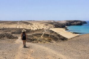
The Los Ajaches Natural Monument is home to some of the most beautiful beaches in Lanzarote, and the Papagayo Coastal Trail is one of the best ways to explore this stunning corner of the island.
This pleasant seaside walk connects the different coves of Papagayo, offering spectacular views of turquoise waters, golden cliffs and, on clear days, the neighbouring island of Fuerteventura.
One of the great advantages of this route is its flexibility. Depending on how much time you have and how far you feel like walking, it can be enjoyed as a short and easy stroll by the sea or as a longer coastal hike along Lanzarote’s southern shoreline.
Why choose this hike?
Difficulty: Moderate
Duration: 3–4 hours
Distance: Approximately 10 km
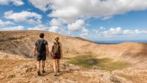
For many hikers, Caldera Blanca is the most spectacular trail in Lanzarote.
This volcano is home to one of the largest craters in the Canary Islands, with a diameter of over one kilometre. The hike begins across the striking malpaís formed during the historic eruptions of Timanfaya, before gradually climbing towards the rim of the caldera.
Once at the top, you’ll be rewarded with extraordinary 360-degree views over the volcanoes of Timanfaya National Park and much of Lanzarote’s dramatic volcanic landscape. It’s a route that offers a real sense of scale, silence and immersion in the island’s raw natural beauty.
What makes this hike special?
💡 W2W tip: Before setting off, make sure to bring plenty of water, sun protection and proper footwear, as much of the route crosses exposed volcanic terrain with little shade. To better understand the origin of this extraordinary landscape, we also recommend visiting the Mancha Blanca Visitor Centre, which offers an excellent introduction to Lanzarote’s geological history.
Difficulty: Easy
Duration: Around 3 hours
Distance: 8 km
This beautiful coastal walk links Tenesar, a small and peaceful fishing village facing the Atlantic, with La Santa, one of Lanzarote’s best-known spots for surfing and ocean life.
The trail follows the island’s striking western coastline, passing through volcanic terrain, sea-sculpted cliffs and wide-open views over the Atlantic. It’s an ideal route for travellers who want to slow down, connect with nature and discover one of the least touristy parts of Lanzarote.
Reaching La Santa is the perfect way to end the walk: you can stop for lunch by the ocean, enjoy the laid-back atmosphere of the village or simply stay to watch the sunset over the sea.
Why choose this hike?
💡 W2W tip: This is a wonderful route for late afternoon, when the light softens the volcanic coastline and the Atlantic becomes even more dramatic. If you can, plan your walk so you reach La Santa around sunset.
Difficulty: Easy to moderate
Duration: 3 to 5 hours
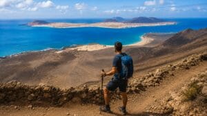
For travellers looking for an even wilder and more authentic experience, La Graciosa offers some of the most evocative hiking routes in the entire Canary Islands. With almost no paved roads, a slow island rhythm and wonderfully untouched landscapes, every walk here feels like a true escape from everyday life.
One of the most classic and accessible routes starts in Caleta de Sebo, passes by the beautiful Playa de La Francesa and continues towards Montaña Amarilla. It’s a mostly flat walk, making it a great option even for hikers with little experience.
Those in search of a more adventurous route can head towards the spectacular Playa de Las Conchas, often considered one of the most beautiful beaches in the Canary Islands, or make their way up to Montaña Bermeja, where breathtaking views open up over La Graciosa’s wild beaches and the northern coast of Lanzarote.
Why go hiking in La Graciosa?
💡 W2W tip: Hiking is just one of the many ways to experience La Graciosa. The island can also be explored by bike, on a jeep or 4×4 taxi excursion, or from the sea on a catamaran trip. In our “Lanzarote and its beaches” itinerary, you’ll find practical tips and inspiration for planning your visit to La Graciosa.
Difficulty: Moderate to challenging
Duration: 4–5 hours
Distance: Approximately 8 km
Camino de los Gracioseros is one of the most fascinating historic and scenic trails in the Canary Islands. For centuries, the inhabitants of nearby La Graciosa used this steep path to reach Lanzarote and trade with the people of Haría.
The route runs along the majestic Risco de Famara, a dramatic cliff rising around 500 metres above sea level and overlooking the Chinijo Archipelago. Through a series of zigzags, the trail descends towards Playa del Risco, one of the wildest and most unspoilt beaches in Lanzarote.
The effort is more than rewarded by the extraordinary scenery: golden sand, crystal-clear water and breathtaking views over La Graciosa and the surrounding coastline.
Of course, everything you descend, you also have to climb back up. The return hike along the Camino de los Gracioseros requires a good level of fitness and should be tackled at a steady pace, especially on warmer days.
Why is it worth it?
For travellers who want to discover Lanzarote in a truly authentic way, there is the possibility of crossing the entire island on foot by following the GR-131, the long-distance trail that links Órzola, at the northern tip of the island, with Playa Blanca in the south.
The route is around 71 kilometres long and is usually divided into five stages, allowing walkers to experience some of Lanzarote’s most representative landscapes along the way: volcanoes, wide stretches of jable (the island’s fine volcanic sand), vineyards, traditional villages and dramatic scenery shaped by volcanic eruptions.
Órzola – Haría This stage crosses the La Corona Natural Monument before reaching the beautiful Valley of a Thousand Palm Trees in Haría.
Haría – Teguise. A spectacular section that passes through the heights of Peñas del Chache, the highest point in Lanzarote.
Teguise – San Bartolomé. A route through the island’s rural heart, surrounded by traditional agricultural landscapes and quiet inland scenery.
San Bartolomé – Yaiza. This stage leads through the heart of La Geria, Lanzarote’s extraordinary wine-growing region, where vineyards spread across black volcanic soil.
Yaiza – Playa Blanca. The final stretch skirts the Los Volcanes Natural Park before reaching the crystal-clear waters of southern Lanzarote.
Much more than a hiking route
More than just a long-distance trail, the GR-131 is a true journey through the soul of Lanzarote. Over the course of a few days, it reveals all the different faces of the island known as La Isla Diferente: its volcanoes, traditions, rural landscapes, natural heritage and the extraordinary way its people have adapted to one of the most unique environments in the world.
Before setting off on any hike, it’s always a good idea to check the current trail conditions, the level of difficulty and any possible access restrictions.
Some of the most useful resources for planning your hikes in Lanzarote include:
💡 W2W tip: If hiking isn’t the main focus of your holiday but you’d still like to include one or two walks during your stay, you can easily combine them with World2Wander’s themed itineraries focused on Lanzarote’s beaches, César Manrique’s artistic legacy, some of the island’s lesser-known corners and its local gastronomy.
One of Lanzarote’s greatest advantages is its mild climate all year round. In general, the best months for hiking are from October to May, when temperatures are more comfortable and the wind is usually less intense. Hiking is still possible in summer, but it’s best to set off early in the morning or later in the afternoon to avoid the hottest part of the day.
Volcán del Cuervo is probably one of the most beautiful sunset hikes on the island, thanks to the way the evening light transforms the crater and the surrounding lava fields. The Tenesar area and several viewpoints along the island’s west coast also offer unforgettable sunsets over the Atlantic Ocean.
Many hikers consider Caldera Blanca to be the most spectacular trail on the island. From the rim of its enormous crater, you can enjoy extraordinary views over Timanfaya National Park and a huge part of Lanzarote’s volcanic landscape.
Yes. Most of Lanzarote’s hiking trails are well signposted and can be done without a guide. That said, it’s always a good idea to check the weather forecast, let someone know your planned route and carry enough water, especially if you’re heading into more remote areas with little shade.
Yes, but only as part of guided walks organised by the National Park itself. Access to certain areas is restricted, and advance booking is usually required through the park’s official channels.